More than fifty years ago, in 1972, I attended a postgraduate course at the International
Institute for Aerial Survey and Earth Sciences (ITC) in the Netherlands. A key part of the
course involved stereoscopic examination and measurement of aerial photographs. At that
time, photogrammetric measurements were carried out using large optical-mechanical
instruments and plotting systems, such as the Topocart.
Working with hundreds of aerial photographs often meant quickly identifying which two
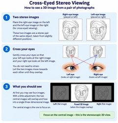
photographs formed the required stereo pair. I learned a simple, extremely useful technique:
by crossing my eyes slightly, I could fuse two overlapping photographs and see the terrain in
three dimensions without a stereoscope.
I have retained this ability ever since. Whenever I see two photographs of the same object
taken from slightly different positions, whether aerial, close-range, terrestrial or even from a
spacecraft, my first instinct is to place them side by side and try to view them
stereoscopically.
Today, digital images and video sequences offer remarkable opportunities to do this. Images
obtained during lunar missions such as Artemis, from Mars exploration missions, from the
Ingenuity helicopter on Mars, and from photographs of archaeological objects can sometimes
be selected or processed to produce fascinating stereo pairs.